| Home | Newsletter | Locations | Diary |
| Indexes |
|
| Travellers Resource |
|
|
|
|
"A part of the World Heritage Site - Stonehenge, Avebury and Associated Sites"
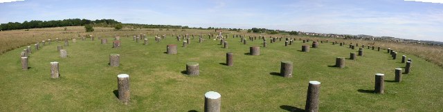
Woodhenge Panorama by
Elaine Owen
Woodhenge is located only a short distance, 2
miles NE of
Stonehenge,
It is a part of the World Heritage Site covering Avebury, Stonehenge and associated sites. Woodhenge was discovered from an aerial photograph taken in 1925. It was first excavated in 1926 and 1929. There were more excavations in the 1970's and in 2006. The earlier excavations found holes of 2 stones and 169 post holes. The latest found a larger number of stone holes arranged in a cove. The deepest of the post holes are 2 metres deep, and this would support a timber post up to 7.5 metres above the ground. These posts would have weighed up to 5 tonnes each and are arranged similar to the bluestones at Stonehenge. Other similarities with Stonehenge are that they both have entrances oriented approximately on the midsummer sunrise and the diameters of the timber circles at Woodhenge and the stone circles at Stonehenge are similar. No one knows its use, there are suggestions that it is connected with the progress of the sun, but with 169 posts and some stones, some are sure to line up with any theory. There are many other features in this landscape that still are visible nearby and probably many more that are yet to be found. These similarities and being geographically near Stonehenge was the reason behind its name. The structure is a ditch and outer bank, with 6 rings of post holes. The entrance through the bank and ditch is in the north east, as at Stonehenge. In 1966 around 500 metres away another timber
circle of similar size as discovered at
Durrington
Walls. In the earlier excavations two bodies were found, a child near the centre with its skull split open, and a teenager in one of the ditch sections. The child was said to be a dedicatory sacrifice, the body was destroyed in the London Blitz in the Second World War. However the English Heritage website dates this find as later in the 1970's. A variety of pottery was found dating from the Neolithic period. It is said to date from 2,300BC. How it was discovered Sqn. Ldr. Insall was an experienced flyer, who had been awarded the Victoria Cross for his gallantry in the Great War, (1914-18) and was familiar with this landscape. Sqn. Ldr. Insall, flying a Sopwith Snipe in the early summer of 1925, was looking at the many barrows and the remains of the large circle at Durrington Walls. One of these differed from others in that it had white spots within it. He noticed that these were in a circle and there was a similarity with the arrangement of Stonehenge nearby. By June darker areas within crops marked out soil disturbances not visible on the ground. Considering it merited further investigation he photographed it from the air. Excavations were carried out over the following three years by the Wiltshire Archaeological team of Mr and Mrs B H Cunnington.
.
Please let us know any other information that we can add to the Further information and Planning Grids or page and any errors that you discover. Before making a long trip to any location it is always wise to double check the current information, websites like magazines may be correct at the time the information is written, but things change and it is of course impossible to double check all entries on a regular basis. If you have any good photographs that you feel would improve the illustration of this page then please let us have copies. In referring to this page it is helpful if you quote both the Page Ref and Topic or Section references from the Grid below. To print the planning grid select it then right click and print the selected area. Please submit information on locations you discover so that this system continues to grow.
|
||||||||||||||||||||||||||||||||||||||||||||||||||||||||||||||||||||||
. |
||||||||||||||||||||||||||||||||||||||||||||||||||||||||||||||||||||||
|
||||||||||||||||||||||||||||||||||||||||||||||||||||||||||||||||||||||
|
|